Sedona Evacuations as Oak Creek Floods Arizona
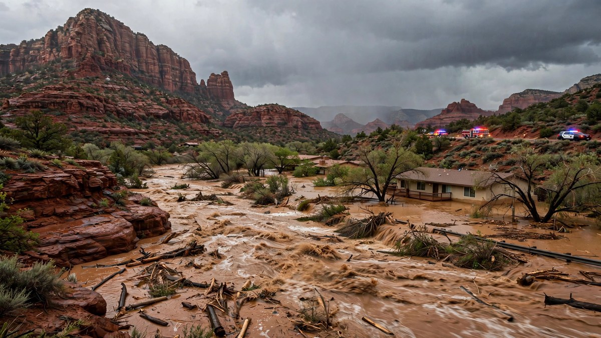
SEDONA, Ariz. — Flash flooding forced mandatory evacuations in Sedona on Sunday as Oak Creek surged from a trickle to a raging torrent overnight, trapping residents in their homes, closing highways across northern Arizona and sending rivers toward record crests that were still rising into the evening.
The City of Sedona moved evacuation zones 8, 9 and 10 along Oak Creek to “Go” status at 9:45 a.m. Eastern on Sunday, telling residents to leave immediately and head to Sedona Red Rock High School. Firefighters called in extra crews as water rescues piled up, and Arizona’s Department of Public Safety carried out rooftop rescues after floodwater trapped people inside their homes. The governor’s office said six such rescues had been completed by Sunday afternoon, with crews still responding to calls for help.
The flooding was part of a wider Southwest deluge. The same storm system that soaked Arizona also forced evacuations in Camp Verde, closed sections of Interstate 17 and State Route 89A, washed out a highway in New Mexico and put a Colorado mountain town on alert for what officials warned could be catastrophic flooding on the San Juan River. By Sunday evening, the National Weather Service said 150 to 200 homes had been affected by flooding in the Lake Montezuma and Rimrock areas of Yavapai County, with structures flooded and roads closed.
Officials urged drivers not to cross flooded roads. The Weather Service repeated its long-standing warning — turn around, don’t drown — and cautioned that flood impacts would continue through the night even as rain eased, because rivers were still rising toward their crests.
Oak Creek surges past flood stage in hours
Oak Creek’s rise was startlingly fast. The federal stream gauge near Sedona read about 210 cubic feet per second at midnight, then 4,580 cubic feet per second at 4 a.m. Eastern and more than 15,500 cubic feet per second by the time the evacuation order went out, according to provisional U.S. Geological Survey data. The creek’s median flow for Nov. 1 is just 31 cubic feet per second.
At Sedona, the creek reached about 15 feet, above its 14-foot flood stage, the point at which access roads, buildings and homes along the creek begin to flood. Downstream near Cornville, the creek climbed to about 18.78 feet by late morning, above its crests in 1995 and 2004 and within half a foot of the 1993 record of 19.15 feet. Gauge readings are provisional and can be revised, but the scale of the surge was not in doubt: a creek that residents cross on foot had become a river carrying, at its peak, roughly the equivalent of six Olympic swimming pools of water every second.
Between 1.5 and 2.25 inches of rain had fallen around Sedona by about 10:30 a.m. Eastern, the National Weather Service said, with more rain expected. Flooding was reported near Tlaquepaque, the Sedona shopping village, where a walkway under the bridge closed as water rose.
“We are getting two or three months of rain in a span of a couple of days,” Aaron Hardin, a meteorologist with the National Weather Service in Tucson, said of conditions across the region. The latest round of soaking rain began Saturday evening and was expected to bring flash flooding to already saturated ground through Monday, with as much as 4 inches of rain possible across parts of the region, fueled by a series of Pacific storm systems.
Verde River evacuations spread to Camp Verde
The danger did not stop at Sedona. The Verde River, into which Oak Creek flows, surged to 22.47 feet at Clarkdale by 6 p.m. Eastern on Sunday, far above its 12-foot flood stage and into major flood territory. Near Camp Verde, the river was forecast to crest at 24.33 feet at 3 a.m. Eastern on Monday, above a 17-foot flood stage at which homes along the river are inundated.
Residents near the Verde River, West Clear Creek and Wet Beaver Creek in the Camp Verde area were ordered to evacuate around noon Eastern on Sunday, with a temporary shelter set up at the Camp Verde Parks and Recreation gym. Evacuation orders were also issued in parts of Gila County, including the entire community of Gisela, where a shelter was opened in Payson.
In Yavapai County, the Lake Montezuma and Rimrock areas along Wet Beaver and Dry Beaver creeks were among the hardest hit by Sunday evening, with emergency management reporting 150 to 200 homes affected. Farther south, the Salt River near Chrysotile reached 18.7 feet on Sunday evening, above its previous crest of 18.3 feet set on Jan. 8, 1993.
In the Tucson area, swift-water rescues were reported after 1 to 2 inches of rain fell, and in the Phoenix area, law enforcement reported multiple water rescues on Sunday evening in Scottsdale and Phoenix, including along Loop 101, under a considerable, life-threatening flash flood threat.
Highways closed across northern Arizona
Flooding, rockfalls and debris forced the closure of multiple routes on Sunday. State Route 89A between Sedona and Kachina Village was closed, along with State Route 73, State Route 238 and sections of Interstate 17. The Arizona Department of Transportation said crews were using plow trucks to clear rockfall and debris from northern routes, and there was no immediate reopening timetable for several roads. Interstate 17, which had been closed in northern Arizona, was later reopened in both directions, but other highways remained shut.
Coconino County activated its emergency operations center to coordinate evacuation information, sandbag distribution and road-closure updates. Officials warned that Sedona’s narrow creek corridors make flash flooding sudden and dangerous, threatening residents, overnight visitors and regional travel — and that closures could last if more heavy rain arrives.
Colorado and New Mexico also hit
In southwestern Colorado, officials in Pagosa Springs warned of potentially “catastrophic flooding” as the San Juan River was forecast to crest at more than 19 feet late Sunday night. Residents in low-lying areas along the San Juan, Rio Blanco, Navajo and Piedra rivers were told to head to a designated shelter at a local church and not to wait, because emergency crews could be extremely limited during the worst of the storm. The highway into the hot-springs town was shut to inbound traffic on Sunday afternoon.
In New Mexico, emergency managers reported Highway 170 washed out between mile markers 3 and 18 in San Juan County, with a flash flood warning in effect into Sunday evening for northern Farmington, Aztec, Flora Vista, Cedar Hill and La Plata.
The weekend flooding was the second historic flood event in about ten days for the Four Corners region, which had already been devastated by flooding in the San Juan River basin a little more than a week earlier. Forecasters said the severe weather risk with this system would shift east on Monday, toward the central United States.
What happens next
River levels were expected to remain dangerous into Monday even where rain had stopped. The Verde River near Camp Verde was forecast to crest in the early hours of Monday, and Moenkopi Wash near Tuba City was expected to crest at 29.45 feet at 7 a.m. Eastern on Monday, above a 27-foot flood stage at which water begins to encroach on homes in lower Moenkopi Village.
Residents in evacuated areas were told to stay away from creek beds and washes, never to drive through flooded roads, and to check with county emergency officials before returning home, since roads can remain washed out or covered in debris long after water levels fall. Anyone in immediate danger was told to call 911.
For travelers, the message from Arizona officials was blunt: do not attempt to drive around barricades or through rushing water. Just a few inches of fast-moving water can sweep a car away, and most flood deaths in the United States happen in vehicles.
Frequently asked questions
Why did Sedona evacuate on Sunday?
The City of Sedona ordered evacuation zones 8, 9 and 10 along Oak Creek to leave immediately after the creek rose above flood stage overnight, trapping residents in homes and flooding access roads. The evacuation shelter was Sedona Red Rock High School.
How high did Oak Creek get?
At Sedona, Oak Creek reached about 15 feet, above its 14-foot flood stage, after flowing at roughly 210 cubic feet per second at midnight. Near Cornville it climbed to about 18.78 feet by late morning, above its 1995 and 2004 crests. Gauge readings are provisional.
Which Arizona highways closed?
State Route 89A between Sedona and Kachina Village, State Route 73, State Route 238 and sections of Interstate 17 were affected. Interstate 17 was later reopened in both directions, but several other routes remained closed with no immediate reopening time.
Is the flooding over?
No. Rivers including the Verde River were still forecast to crest in the early hours of Monday, and officials warned that flood impacts would continue through the night even where rain had eased. Residents should follow county evacuation orders and road closures.
Sources
Reporting for this article drew on the Associated Press, AZCentral, the National Weather Service and U.S. Geological Survey gauge data, and regional flood tracking. See: AZCentral: Arizona flooding triggers evacuations, highway closures; AP via La Nación: Flash floods trigger evacuations in Arizona and Colorado; Storm Recovery Hub: Southwest floods tracker, updated Nov. 1; Dispatch Times: Arizona downpours force evacuations, shut roads.
Related coverage on NationWire: Southwest Flooding: New Atmospheric River Threatens Arizona and New Mexico